Search Results

Keyword: ‘infrastructure’

Map of the Day

November 14th, 2012 No comments

As Congress Contemplates A $50 Billion Federal Bailout of NY and NJ 

(source: US Fish and Wildlife Service)

Coastal Barrier Resources Act

The Coastal Barrier Resources Act15 was passed in 1982 and established the John H. Chaffee Coastal Barrier Resources System (CBRS) to minimize the loss of human life, wasteful federal expenditures, and damage to fish, wildlife, and other natural resources associated with coastal barriers, such as barrier islands. The Act defines coastal barriers as “bay barriers, barrier islands, and other geological features composed of sediment that protect landward aquatic habitats from direct wind and waves.”16 As part of the program, which is administered by the U.S. Fish and Wildlife Service, the federal government discourages development on designated coastal barriers by restricting certain federal financial assistance, including flood insurance coverage, loans, funding for U.S. Army Corps of Engineers development projects, and construction of sewer systems, water supply systems, and transportation infrastructure. 

The CBRS is specifically designated on maps maintained by the Secretary of the Interior. The Secretary is directed to review and update the maps every five years to reflect the changes in size or location of any of the barriers. Nearly 1.3 million acres of land, wetlands, and water along the East Coast, Great Lakes, and Gulf of Mexico are part of the “full system unit,” with “otherwise protected areas” covering an additional 1.8 million acres of coastal barriers already held for conservation or recreational purposes. The program does not ban development in these areas; rather, it creates disincentives by denying federal subsidies and imposing the full costs of development on the developer or property owner. 

The CBRA is administered by the US Fish and Wildlife Service:

What is the Coastal Barrier Resources Act?


In the 1970s and 1980s, Congress recognized that certain actions and programs of the Federal Government have historically subsidized and encouraged development on coastal barriers, resulting in the loss of natural resources; threats to human life, health, and property; and the expenditure of millions of tax dollars each year.  To remove the Federal incentive to develop these areas, Congress passed the Coastal Barrier Resources Act (CBRA) of 1982 which designated relatively undeveloped coastal barriers along the Atlantic and Gulf coasts as part of the John H. Chafee Coastal Barrier Resources System (CBRS), and made these areas ineligible for most new Federal expenditures and financial assistance. Learn more …

Taxpayer Savings


In the past, certain actions and programs of the Federal government had the effect of encouraging development of fragile, high-risk, and ecologically sensitive coastal barriers. The Coastal Barrier Resources Act (CBRA) of 1982 and its amendments limit Federal expenditures and financial assistance which have the effect of encouraging development on designated coastal barriers. The result is a savings in Federal dollars, the protection of human lives, and conservation of natural resources. CBRA and its amendments do not prevent or regulate development, they only remove the Federal incentive for development on designated coastal barriers. Therefore, individuals who choose to live and invest in these hazard-prone areas bear the full cost of development and rebuilding instead of passing it on to American taxpayers. An economic study conducted by the U.S. Fish and Wildlife Service in 2002 estimated that by 2010, CBRA will have saved American taxpayers approximately $1.3 billion by restricting Federal spending for roads, wastewater systems, potable water supply, and disaster relief.

The savings estimated in this study are conservative for the following reasons: the Federal programs Congress directed the Service to examine comprise but a fraction of the Federal programs, policies, and funding sources that promote, protect, and rebuild development along our coasts; the methods the Service used to estimate Stafford Act savings assume the cost per developed acre in the entire disaster area is constant, but this is not generally the case; costs for infrastructure did not consider the geology of coastal barriers and how much more expensive it is to build in these places because they are unstable and flood prone; the Service assumed no construction occurred on wetlands, which has probably happened in some areas; the Service only considered initial, on-site construction costs, but did not assess the costs of operating and maintaining infrastructure or connecting development to existing facilities.

The Coastal Barrier Resources Act, Harnessing the Power of Market Forces to Conserve America’s Coasts and Save Taxpayers’ Money.

Categories: Uncategorized Tags:

State Planning Commission Delays Adoption of Christie Strategic Plan

November 13th, 2012 2 comments

Sandy exposed fatal flaws in failing to address climate change, land use, and infrastructure

A huge opportunity for positive change – I urge my friends to go large.

[Update: 11/14/12 – Tom Johnson at NJ Spotlight covers the hearing well:

Administration Fails to Push Revised State Plan Through at Contentious Hearing:

[…]

“This plan cannot be a framework for coastal recovery,’’ said Bill Wolfe, director of the New Jersey chapter of Public Employees for Environmental Responsibility (PEER). He criticized the revision as an economic development strategy that ignores the land-use mandates at the core of the prior state plan. – end update]

The State Planning Commission met this morning.

The published agenda for the meeting – public noticed late friday, a move that prompted criticism from all quarters as limiting public review – was to finally adopt the Christie Administration’s “Strategic Plan”, it’s version of the State Development and Redevelopment Plan.

The Commission pulled the vote at the last minute and instead had the plan up for discussion only.

At a time when DEP Commissioner Martin is denying any state role in coastal redevelopment and already has deregulated the rebuilding of critical public infrastructure, thank goodness sounder judgement prevailed and someone at the State level assumed responsibility.

(Riffing on the cliff motif, what I called a “step back from the land use cliff”).

At the start of the meeting, the Commission immediately went into a brief executive session and returned shortly to issue a brief prepared statement, explaining the rationale for postponing a vote on adoption of the final Plan.

The Commission expressed sympathy for families and businesses impacted by Sandy. They expressed hope that the State was getting back to business, so important matters could continue.

Perhaps in recognition of the criticism of the friday afternoon public notice, the Commission noted that many haven’t had ample opportunity to review the changes to the final version of the Plan. They claimed that those changes incorporate public comment, leading to a better plan.

At the same time, however, professionals in the Office of Planning Advocacy recommended postponing adoption today – because “mother nature had other ideas”.

Importantly, the statement emphasized that the final Plan could be “a framework for rebuilding the coast”, but that there need to be “further additions with long term coastal recovery in mind.”

The Commission pledged to “do additional outreach to impacted stakeholders“, alluding to those impacted by Sandy and those looking to redevelop the shore.

During public testimony, leaders of environmental groups criticized the Christie Plan as promoting development at the expense of the environment, particularly in the Highlands.

ANJEC, The Affordable Housing Coalition, and NJ Future continued to support the framework of the plan, but called for more details, especially on locational and natural resource criteria to identify where development should occur and where environmentally sensitive lands should be preserved.

I reiterated the highlights of my prior “Yes Men” testimony, where I focused on fatal flaws in the plan (for substance, see this and this and this).

Sandy had vindicated those views and has shone a bright light on the fatal flaws in Christie’s “Strategic Economic Development Plan”:

  • A Strategic Economic Development Plan can not substitute for a Land Use Plan
  • the Christie Plan fails to seriously engage climate change policy
  • the Christie Plan fails to address infrastructure deficits, vulnerability, and investment finance

Here were my main talking points:

1) The shore devastation is a final wakeup call, so that we now take climate change and extreme weather seriously.

2) The shore devastation requires that State Government step up and get involved in land use planning for “strategic retreat” and rebuilding.

3) The shore devastation requires that infrastructure vulnerability and resilience be addressed substantively.

4) Sandy made a mockery of Christie’s economic development strategy and shows that economic development is reliant on functioning natural systems and reliable infrastructure.

5) The Christie Strategic Plan is not an appropriate framework for shore redevelopment  because it lacks a land use planning orientation and adequate infrastructure policies. Nor is the Commission the appropriate governing body.

Instead, there needs to be a broader legislative and public dialogue, and a new institution  formed. I suggested a Coastal Commission.

After an hour or so of gibberish attacks from delusional Tea Party types, the Commission adjourned.

But not before the Chairman made a strong personal statement about the new reality of global warming.

Overall, I was encouraged by the OPA recommendations and the Commission’s good judgment to table the Christie plan in light of Sandy and coastal redevelopment needs.

There could be a huge opportunity for positive change here –

I urge my friends to go large on global warming, adaptation, and coastal land use planning, including calling for legislative oversight hearings and a new Coastal Commission!

Categories: Uncategorized Tags:

Storm of Denial – Why Is Christie DEP Still in Denial and Lying About State Role in Coastal Hazards?

November 12th, 2012 4 comments

This is NOT Sandy (source: NJ Sea Grant "Manual for Coastal Hazard Mitigation")

To Get to Resilience, We Must Get Past Denial and State Abdication

Waist Deep in the Big Muddy – The Big Fools Says to Push On

“We have this insane mentality, this boosterism along the coast,” said Wolfe, the former state environmental official in New Jersey. “For years and years, people have been putting up warning flags. The state has known this, and instead of regulating more restrictively they’ve pushed right ahead.”

Larry Ragonese, a spokesman for the state’s Department of Environmental Protection, argued that development along the Jersey Shore has been ongoing for decades, even before there was a coastal permitting program. He said it is not the state’s role to dictate how redevelopment should occur.

“People who live along the shore always live with a risk, and they know that. That’s understood,” he said. “We at the state are not going to tell these towns you can or cannot rebuild, but we will work with them to make sure that whatever comes back will be done in as smart or protective a fashion as possible.”~~~ Huffington Post 11/12/12  

[Watch HuffPost Live Panel discussion]

Why is DEP so deep in denial and lying about it ? (for illustration, see DEP press office comments in the above HuffPo story and in today’s Bergen Record story)

The above photo is the cover of a Report titled: NEW JERSEY SEA GRANT COLLEGE PROGRAM MANUAL FOR COASTAL HAZARD MITIGATION . If that is not an unheeded warning, I don’t know what is.

DEP’s legal responsibility is clear – the DEP Press Office can not credibly deny this.

DEP press office statements directly contradict  NJ law, which requires that DEP regulate land use, development, and infrastructure in the coastal zone.

Under the federal Coastal Zone Management Act (CZMA) and the NJ Coastal Area Facilities Review Act (CAFRA) DEP is legally responsible as the lead for coastal management. Under both federal and state law, DEP also is responsible for planning and permitting of critical public infrastructure, including sewer and water.

State government has additional coastal land use and infrastructure responsibilities under the NJ State Planning Act.

Why is DEP denying all this? Particularly, these 3 aspects:

  • DEP conducted a pilot storm risk reduction program along the shore (aptly titled: “Getting To Resilience”) and in March 2012, DEP issued a directly on point Report: NJ Coastal Community Resilience Report, which states:

“Coastal Community Vulnerability Assessment Protocol (CCVAP) is a GIS-based methodology to assist land use planners, hazard mitigation planners, emergency managers, and other local decision-makers in the identification of their community’s vulnerability through virtual mapping. By applying the methods defined in CCVAP to the pilot communities, areas were identified where built infrastructure, sensitive natural resources, and special needs populations overlapped areas of potential inundation. This vulnerability mapping supports community efforts to make the connection between the potential consequences of sea level rise and inundation to their vulnerability – ultimately toguide the community for resilience planning.

Getting to Resilience is a questionnaire developed as a non-regulatory tool to help coastal communities build capacity for resilience to coastal hazards and sea level rise. The application of the survey was intended to highlight positive actions already underway within the pilot communities and to identify opportunities to improve local resilience through planning, public outreach, mitigation, and response mechanisms. This questionnaire validates the hazard planning that the communities have begun to implement and identifies opportunities to incorporate adaptation strategies in broader community planning.”

That DEP Vulnerability Assessment Report found:

The scientific community has arrived at a strong consensus that global climate change is occurring and resulting in changes to shoreline dynamics1. Climate change threatens to accelerate sea level rise and increase the frequency and intensity of coastal storms. As a result, citizens, development, and ecosystems will become more vulnerable to the impacts of coastal hazards, making it imperative to identify areas where special needs communities, vital public facilities and roads, and sensitive natural resources overlap areas of potential inundation. These issues need to be considered as New Jersey’s coastal communities plan to become more resilient.

  • As required by the federal CZMA, every 2 years DEP prepares a Coastal Hazard and Vulnerability Assessment Report – here’s the relevant DEP findings from the DEP’s Section 309 Coastal Hazards Assessment:

“Many parts of New Jersey’s densely populated coastal area are highly susceptible to the effects of the following coastal hazards: flooding, storm surge, episodic erosion, chronic erosion, sea level rise, and extra-tropical storms. Reconstruction of residential development and the conversion of single family dwellings into multi-unit dwellings continues in hazardous areas… the value of property at risk is increasing significantly. With anticipated accelerating sea level rise and increasing storm frequency and intensity, vulnerability to the risks of coastal hazards will not abate; it will only become more costly. […]

…in certain instances, structural engineering solutions will not be practical or economically feasible. In these cases future public and private development and redevelopment must be directed away from the hazardous areas. While some derogatorily refer to this option as “retreat,” from the perspective of sound planning based on the best available science, the concept actually involves “strategic adjustment.” Prudent planning requires that we expand upon the existing studies of the societal, economic, and environmental costs of possible mitigative actions while the greatest number of alternatives exist.”

“While the State Development and Redevelopment Plan has promoted sustainability from its beginnings, it has been less consistent in promoting resilience, defined as accounting for, or mitigating (by reducing risk and vulnerability), costs reasonably anticipated during the life of each infrastructure project, including disruption from natural or manmade hazards. Compartmentalization (“silos”) of infrastructure investment decision making, both within and across state agencies and between local and state governments, is still a problem.”

This level of denial and abdication warrant legislative intervention and federal regulatory oversight.

Categories: Uncategorized Tags:

Leadership Matters – How DEP Buried Report on Coastal Storm Risks

November 5th, 2012 5 comments

DEP Neutered Its Own Coastal Management Professionals and Programs

Climate Adaptation Work Like the Proverbial Tree Falling in the Forest

Commissioner Martin should be called before legislative oversight hearings

During a hike in the woods yesterday, I got a call from a reporter asking about my various strong criticisms of the State’s lack of preparedness and planning and response to “Superstorm Sandy”.

One question he asked was whether there were technical Reports available and whether NJ had conducted pilot studies within defined geographic zones.

I mentioned a series of global warming, adaptation, coastal hazard assessment, and vulnerability assessment work that had been done recently that documented and warned about the problems we were now experiencing (all had been previously posted with links here).

For a pilot study, I referred him to the Delaware Bay study.

No secret to regular readers here, my conclusion was that all this good work and warnings were being ignored and worse, that the Christie administration was making risks even worse by various deregulatory and pro-economic development policies (and hijacking the CAFRA and State Plan’s land use planning orientation into a corporate economic development strategy).

Under the Christie DEP policy, had the real estate industry not collapsed, there would have been hundreds of more homes built in hazardous coastal locations and millions more in storm damage.

Later, as I walked, upon reflection I realized that all my various criticisms were unfair because they ignored very important work DEP’s Office of Coastal Management recently did on this set of issues (dated 3/15/12).

So, how could it be I wondered, that I was not aware of and some how simply forgot to even mention this work? After I even recently filed an OPRA request for it and written about the issues many times?

Here it is – and it’s right on point:

Coastal Community Vulnerability Assessment Protocol (CCVAP) is a GIS-based methodology to assist land use planners, hazard mitigation planners, emergency managers, and other local decision-makers in the identification of their community’s vulnerability through virtual mapping. By applying the methods defined in CCVAP to the pilot communities, areas were identified where built infrastructure, sensitive natural resources, and special needs populations overlapped areas of potential inundation. This vulnerability mapping supports community efforts to make the connection between the potential consequences of sea level rise and inundation to their vulnerability – ultimately to guide the community for resilience planning.

Getting to Resilience is a questionnaire developed as a non-regulatory tool to help coastal communities build capacity for resilience to coastal hazards and sea level rise. The application of the survey was intended to highlight positive actions already underway within the pilot communities and to identify opportunities to improve local resilience through planning, public outreach, mitigation, and response mechanisms. This questionnaire validates the hazard planning that the communities have begun to implement and identifies opportunities to incorporate adaptation strategies in broader community planning.

(note especially the limit to “local” decisions and the explicit mention of “non-regulatory tools” – any DEP regulation is now taboo!)

This work was like the proverbial tree falling in the forest.

It has been ignored and swept under the rug by DEP Commissioner Martin. Buried in the Bureaucracy.

Now here’s where leadership matters and why “in the weeds” organizational issues are key.

First of all, you won’t find this work anywhere on DEP special “Hurricane Sandy Information” webpage. When an issue is a priority to the Commissioner, it is presented to the public, not kept virtually secret.

Second, you will not find the Coastal Community Vulnerability Assessment Protocol mentioned anywhere in Governor Christie’s Executive Orders, speeches, policy documents, or public remarks. When an issue is a priority to the Governor, he talks about it and it is presented to the public, not kept virtually secret.

For example, you won’t find global warming, sea level rise, storm surge risks included in Governor Christie’s highly touted 10 Point Barnegat Bay Management Plan, yet the Bay was significantly impacted by Superstorm Sandy.

Similarly, like the coastal storm risk issue, there were relevant but generally low profile and downplayed recommendations by Governor’s Nuclear Review Taskforce  regarding flooding and lack of back up power (post Fukushima lessons ignored).

Third, while Martin’s DEP has issued the most press releases ever, on the most mundane and self promotional topics (how can we forget the release on the Polo Classic? – or construction of “Margaritaville?), you will not find any press releases about this March 15, 2012 critically important Coastal Community Vulnerability Assessment Protocol and pilot work along the coast.

Fourth, because there has been no DEP press release there has been little press coverage (I think Kirk Moore of the Asbury Park Press has written a small story or two.)

Fifth, DEP views Coastal Community Vulnerability Assessment as a local responsibility. This is another issue where DEP has abdicated, outsourced, or delegated critical State responsibilities.

Sixth, during storm preparation, in a show of extemely poor judgment, DEP Commissioner Martin found it more important to write a letter to advise local officials about weakening DEP flood hazard regulations than managing real storm risk.

And last, and most importantly, DEP Commissioner Martin has buried the Office of Coastal Zone Management in the DEP bureaucracy.He did the same thing with the Office of Climate Change.

Both those Offices previously were elevated and housed in the Commissioner’s Office and reported directly to the Commissioner. This gave them more resources and influence within DEP.

Instead, while burying climate and the coast, Martin has created several new troubling Offices in the Commisisoner’s Office that report directly to him.

A DEP Commissioner’s priorities matter – coastal management and climate change adaptation were clearly not a priority (and solutions ran counter to Christie policy). 

Commissioner Martin should be called before legislative oversight hearings to explain and defend his priorities – particularly how he hadled the Office of Coastal Zone Management’s Report and pilot study.

  • Why was that community vulnerability Report and pilot study virtually ignored by DEP press Office and regulatory programs, like CAFRA and WQMP?
  • Why were no State funds requested to expand and implement the Report and Pilot study throughout the entire highly vulnerable NJ coast?
  • What are DEP’s plans for assuming a lead State Responsibility in climate change adaptation and coastal vulnerability assessment, adaptation, and risk mitigation planning?
  • When will DEP update flood hazard maps and ratchet down on regulations to prevent putting more people and property in harm’s way?
  • Would Gov. Christie support an end to the CAFRA “right to rebuild” provision?
Categories: Uncategorized Tags:

A Dirge To McHarg and Mumford – Who Are Rolling Over in Their Graves

October 29th, 2012 1 comment

“Ignorance is compounded with anarchy and greed to make the raddled face of the Jersey shore.”

“… there came retribution.” 

Sandy Destruction: “Man Made, Foreseen, Preventable”

My heart breaks.

I moved recently, so had the opportunity to revisit many important books in my library – one of which I am having the joy of re-reading and think of today: Ian McHarg’s 1967 classic: “Design with Nature” (take a look at some visuals of that work).

The introduction to McHarg’s book was written by another towering favorite of mine, Lewis Mumford, whose introduction brilliantly framed the context for the book:

There is still only a small shelf of books that deals with man’s relation to his environment as a whole: not only with the so called physical universe of the planets and the stars, the rocks and soil and the seas, but with the creatures that inhabit the earth – all the forces and animate beings that have helped to make man himself what he is. This part of man’s knowledge of himself was slow to develop; for the early Greek thinkers tended either to examine man in isolation, or to examine nature without noting the presence of man: as if any part of it could be understood except through the instruments and symbols that the human mind provided, for purposes in one way or another furthered man’s own existence.

Design With Nature is a notable addition to the handful of important texts that begin, at least in the Western tradition, with Hippocrates’ famous medical work on Airs, Waters, and Places: the first public recognition that man’s life, in sickness and in health, is bound up with the forces of nature, and that nature, so far from being opposed and conquered, must rather be treated as an ally and friend, whose ways must be understood, and whose counsel must be respected. […]

One cannot predict the fate of a book such as this. But on its intrinsic merits I would put it on the same shelf that contains as yet only a handful of works in a similar vein, beginning with Hippocrates, and including such essential classics as those of Henry Thoreau, George Perkins Marsh, Patrick Geddes, Carl Sauer, Benton MacKaye, and Rachel Carson. This is not a book to be hastily read and dropped; it is rather a book to live with, to absorb slowly, and to return to, as one’s own experience and knowledge increases. Though it is a call to action, it is not for those who believe in “crash programs” or instant solutions: rather, it lays a fresh course of stones on a ground plan already in being. Here are the foundations for a civilization that will replace the polluted, bulldozed, machine-dominated dehumanized, explosion-threatening world that is even now disintegrating and disappearing before our eyes. In presenting us with a vision of organic exuberance and human delight, which ecology and ecological design promise to open up for us, McHarg revives the hope for a better world. Without the passion and courage and confident skill of people like McHarg that hope might fade and disappear forever. [emphases mine]

McHarg begins his book with a chapter of personal biography and philosophy:

This book is a personal testament to the power and importance of sun, moon, stars, the changing seasons, seedtime and harvest, clouds, rain, rivers, the oceans and the forests, the creatures and the herbs. They are with us now, co-tenants of the phenomenal universe, participating in that timeless yearning that is evolution, vivid expression of time past, essential partners in survival and with us now evolved in the creation of the future.

Our eyes do not divide us from the world, but unite us with it. Let this be known to be true. Let us then abandon the simplicity of separation and give unity its due. Let us abandon the self-mutilation which has been our way and give expression to the potential harmony of man-nature. The world is abundant, we require only a deference born of understanding to fulfill man’s promise. Man is that uniquely conscious creature who can perceive and express. He must become the steward of the biosphere. To do this he must design with nature.

Ironically, his first substantive chapter to apply that lofty design philosophy is focused on a study of the NJ shore!

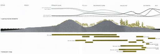
Titled “Sea and Survival“, McHarg presents fundamental dynamics and ecology of the barrier island, explaining clearly the relationships between ocean; beach; primary, secondary and back dunes; the bayshore and the bay.

McHarg concludes this presentation with planning principles and “positive recommendations” about the development and protection of the shore, a call for ecological based planning:

Sadly, in New Jersey, no such planning principles have been developed. While all the principles are familiar to botanists and ecologists, this has no effect whatsoever upon the form of development. Houses are built upon dunes, grasses destroyed, dunes breached for beach access and housing; groundwater is withdrawn with little control, areas are paved, bayshore is filled and urbanized. Ignorance is compounded with anarchy and greed to make the raddled face of the Jersey shore.

McHarg then presents the predictable outcome of this ignorance and greed:

From the fifth to the eighth of March 1962 , there came retribution. A violent storm lashed the entire northeast coast from Georgia to Long Island. For three days sixty-mile-an-hour winds whipped the high spring tides across a thousand miles of ocean. Forty-foot waves  pounded the shore, breached the dunes and filled the bay, which spilled across the islands back to the ocean. When the storm subsided, the extent of the disaster was clear. Three days of storm had produced eighty million dollars worth of damage, twenty-four hundred houses destroyed or damaged beyond repair, eighty-three hundred houses partially damaged, several people killed and many injured in NJ alone. Fires subsequently added to this destruction; roads were destroyed, as were utilities.

Fast forward 50 years – welcome Hurricane Sandy and the know-nothings running corporate America. (XPN is playing Allman’s “Stormy Monday” as I write this – chills all up and down my spine!)

So, in a dirge to McHarg and Mumford (and as the media again swings and misses at the real story), today we repost this July 2012 post, which was done in the wake of the Monmouth water line collapse. The circumstances clearly differ, but the underlying message is the same.

For NJ American Water, DEP, BPU, and Sustainable Jersey

July 6th, 2012 

Man Made, Foreseen, Preventable

“Rosebud”


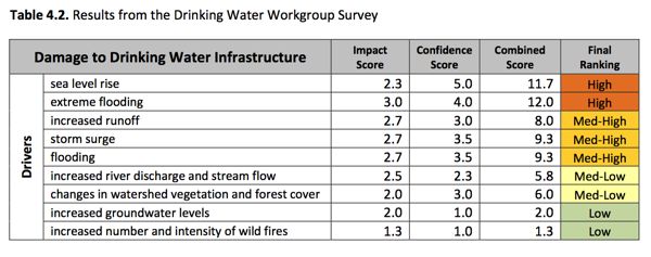
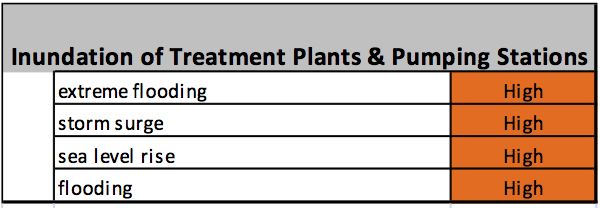
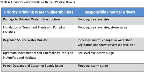
Inundation of Treatment Plants and Pump Stations/Damage to Drinking Water Treatment Infrastructure

Regional Level Action ~ Update 100‐year and 500‐year Floodplain Maps

Regardless of the quality of science available to determine the impacts of climate change on physical conditions in the Basin, specific inundation risks can only be effectively evaluated with updated shoreline topographical information.

Utility Level Action ~ Evaluate Placement of New Construction and Materials Resiliency

Drinking water utilities should evaluate the placement of new construction, monitoring equipment, and other infrastructure to avoid low‐lying areas or locations vulnerable to storms and other harsh weather  conditions. Ranges of potential flooding should be evaluated using the best available science. Adaptations can be refined as more information becomes available about specific impacts of sea level rise, potential increases in streamflow and other changes in the basin that pose a risk to drinking water utilities. Utilities should also evaluate and incorporate use of more resilient construction materials during day‐to‐day upgrades.

Increased Spills and Accidents/Power Outages and Customer Supply Issues

Regional Level Action ~ Support the XXXXXXXX Regional Early Warning System

The XXXXXXX Regional Early Warning System notifies drinking water utilities in the event of accidental contamination in certain areas of the XXXXXXX Basin. The system provides critical information to utilities so they can respond swiftly and appropriately to unexpected threats. Efforts to expand and improve this system must be supported to ensure the continued protection of drinking water supplies in the Basin.

Addresses: Increased Spills and Accidents
Involves: EPA,XXXX, state government, USCG, municipal government, Offices of Emergency Management

Utility Level Action ~ Evaluate Emergency Response Protocols

At the same time that regional emergency response protocols are being evaluated, water suppliers should conduct assessments of their individual utility emergency response protocols to identify vulnerabilities, fill gaps and develop needed contingency and customer communication plans. Revisiting emergency response plans can help protect utilities in the event of unexpected accidents or spills which may become even more prevalent with changing physical conditions in the Basin.

Addresses: Increased Spills and Accidents, Power Outages & Customer Supply Issues

Utility Level Action ~ Evaluate Customer Notification Needs and Protocols

Analyses show that XXXXXX and XXXXXX  are steadily increasing in the main stem XXXXXXX most likely because of increased development, road salts application, and inputs from wastewater and drinking water treatment. These parameters are not removed during conventional drinking water treatment and could pose problems for special needs customers such as dialysis patients and certain industries. Impacts of climate change on conditions in the Basin may exacerbate rising salinity. Water utilities should evaluate current salinity levels to determine if more frequent notification to special needs customers is required.

Rosebud: name that Report

Categories: Uncategorized Tags: