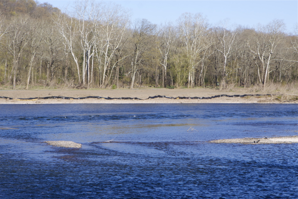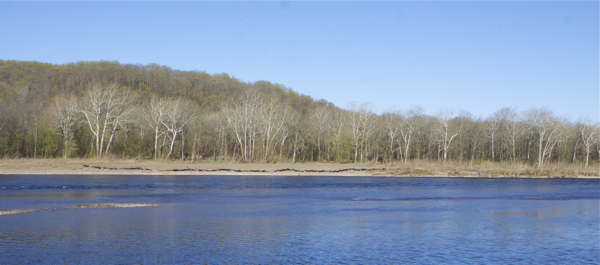
View from Pa. of Bulls Island riverfront bulldozing and fill. Note contrast between fill area and natural vegetation (4/4/12).
Another update, in what is becoming quite a saga, provided in 4 parts: 1) Field progress/photos; 2) Regulatory front; 3) assessment and removal of “dangerous trees”; and 4) correspondence.
1. Small field progress – photos
Photos shot yesterday (4/4/12) from the Pennsylvania side show that a silt fence has been installed along the full length of the 450 foot long bulldozed and filled area. Could not see installation, but did see a few hay bales as well.
Last week, only a 100 foot segment had been installed shoddily, prompting reader comments calling it “a joke”.
We will continue to urge removal of all fill and debris and restoration and revegetation. I would guess that there is about at least 1,000 cubic yards of fill/debris, landfilled in an area of about 3/4 of an acre to an average depth of 2-3 feet.
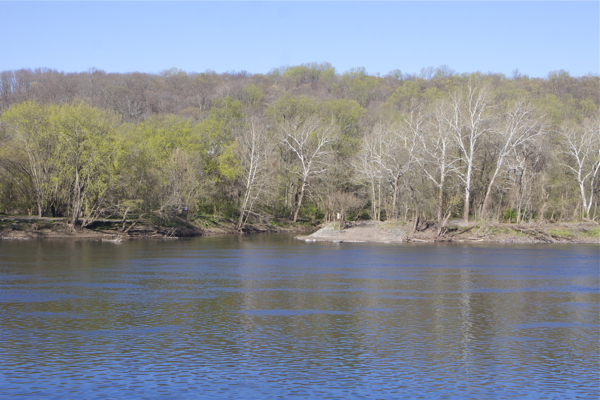
Take a look at and compare the natural riverside floodplain conditions just south of the bulldozed and filled portion:

note difference between shoreline vegetation
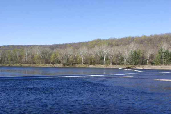
And we were pleased to note that the bulldozer and other construction and dredging equipment is no longer stored at the tip of the Island:

Tip of Bulls Island at river inlet to D&R Canal
2. Regulatory Front
We are getting stymied by the regulators and attacked and spun by the DEP Press Office.
They still are sticking with their original half true but fraudulent cover story that this was just “maintenance dredging” permitted by USACE and NJDEP.
That is almost verbatim exactly what the NJ Water Supply Authority (NJWSA) told me, what the Hunterdon County Soil Conservation District told me, and what DRBC told me. So, the agencies are talking to each other.
Sadly, that same spin (and additional false and misleading assertions) was echoed in an email to area environmentalists by a representative from a so called conservation group Delaware River  Greenway Partnership. So DEP has even deployed their funded minions to downplay the problem and mislead activists.
And it is more than ironic that while the Partnership defends the destruction of soil, vegetation, and habitat on the Island, Â the Partnership has a DEP funded restoration project on the Island designed to:
Volunteers put in more than 300 native plants. Some, like persimmons and big bluestem grass, stabilize the soil to help prevent future erosion. Others provide habitat and food for the island’s wildlife.
Thankfully, that spin is NOT what the USACE project manager; Â the DEP Land Use Enforcement; and D&R Canal Commission staff told me.
So, we still have some integrity remaining in the system.
As we have repeatedly noted – and documented by ground level photos, aerial photos, and site visits – that misleading spin ignores the facts that:
- the D&R Canal dredging violated numerous conditions of the USACE and NJDEP permits (see my letter to USACE and NJDEP enforcement email below); and
- the riverfront bulldozing and fill operation was not permitted and it is unrelated to the permitted dredging project.
Examples of blatant permit violations:
USACE permit condition:
In order to protect anadromous fish species, no dredging shall occur between March 15 and June 30, inclusive, of any year.
In order to protect federally listed bald eagle, no dredging shall occur between December 15 and July 31, inclusive of any year, unless additional consultation between the Corps of Engineers and the US Fish and Wildlife Service takes place for the specific proposed dreading location, and such consultation results in a determination that such work is not likely to adversely affect the species.
All dredged material shall be disposed of at the Rt. 202 site.
FACTS:
I witnessed and photographed dredging on March 10 and March 21. I spoke with and FOIA’d the USACE project manager for all documents and no USACE, NJWSA, USFWS consultations occurred. Dredge material and debris was disposed of along the riverfront. On my March 10 and 21 visits, there were no soil erosion or sediment controls or BMPs installed.
DEP permit conditions that have been violated:
In order to protect State threatened Wood turtle the following conditions are required;
[a-b]
c. No in stream or in canal excavation or dreading is permitted between November 1 to April 1
d. The applicant shall use best management practices incuding, but not limited to the stabilization of all disturbed areas in accordance with the Standards for Soil Eroision and Sediment Control
In order to protect State threatened invertebrate species yellow lamp mussel the following conditions are required;
a. Â … canal work shall be avoided from April 1 – June 30 (glochida release) and August 1 thru October 15 (spawning activity)…
c. the applicant shall use Best Management Practices for sediment generation. […]
If the applicant proposes disturbances to any tributaries or their riparian zones beyond what is authorized by this permit, the applicant must obtain either a Flood Hazard Area (FHA) applicability determination or a FHA permit. ]
The Delaware River is a tributary to the D&R Canal. There was fill and disturbance in the FHA. See above facts which document violations of these DEP permit conditions.
In response to filing FOIA request to the USACE; an OPRA to NJ DEP and a phone call to the NJ Water Supply Authority, Â I received the USACE and DEP permits.
I filed comments to the USACE on numerous permit violations (see below) and will soon submit a similar another complaint letter to NJ DEP regarding violations of their wetlands GP and failure to secure stream encroachment permits.
DEP, D&R Canal and Hunterdon County SCD have not yet responded to my requests for field inspection reports and enforcement documents.
The Huntco SCS inspector made the same mistake DEP Land Use Enforcement originally did by inspecting only the D&R Canal dredge, ignoring the riverfront debacle. I advised the SCS about this and he indicated he would re-inspect, as DEP agreed to as well (see below, where DEP admits this error).
So, we will keep you posted on all that.
3. Assessment and Removal of “Dangerous trees”
We filed an OPRA on that. DEP requested an extension until today, but has denied my request to review the documents today. More foot dragging.
Here’s a photo of the grove of “dangerous trees” on the northern part of the Island, from the wing dam to the tip. This can give you a sense of the number of majestic trees that are at risk of being cut down:

4. Correspondence
Here is DEP Land USe Enforcement email from 3/26/12 – I’ve highlighted the critical stuff. Note how the DEP enforcement supervisor basically tells me that DEP management and Press office will not allow him to share documents:
Dear Mr. Wolfe:
Tanya Hatten inspected the site on March 13 at which time a violation could not be documented. However the activities depicted in the pictures we received from you and from other sources were not observed during that site inspection. I have concerns not only with what I’m seeing in the pictures, but also compliance with the Department’s wood turtle timing restriction.
I’ve asked Tanya to immediately reach out to the park’s manager and NJ Water Supply, advise them of the timing restriction, and schedule a site meeting as soon as possible.
While you are indeed a member of the environmental community you also constitute a member of the press, as such I think that it’s appropriate that I involve the DEP’s press office. You will be updated on our findings in accordance with the press office and management’s directives.
Armand Perez, Region Supervisor
Bureau of Coastal and Land Use
Compliance and Enforcement, NJDEP
Here is my letter to USACE regarding numerous violations of the conditions of the USACE permit:
Mr. Boyer:

Bill it might be time to OPRA e-mails of the DEP NJ Water Supply Authority and Hunterdon County Soil Conservation District and see where the TRUTH LIE?
Great Work Bill.
HCSCD is spineless,and more or less retired on duty. DEP landuse has a conflict, NJWSA was probally just trying to be nice and help out. Army CORP is going to have to have to get this all straightened out. Nice work Bill.
Pingback: WolfeNotes.com » DEP Clear-Cut Plan Would Violate Federal Law
Pingback: garcinia cambogia extract pure walmart
Pingback: WolfeNotes.com » Too Old To Tolerate The Lies