Plans, Planners, and Maps in Exile – What Map Next in Line to Be Killed?

Maps depict serious problems - in this case, polluted drinking water wells
[Important Update Below!]
First they abolished the DEP Office of Policy and Planning, killing the State Planning and coastal planning programs.
Then they killed the Landscape Project Map.
Then they whacked the Water Quality Management Planning Maps showing environmentally sensitive areas where sewers could not be extended.
Then they killed the State Plan Policy Map.
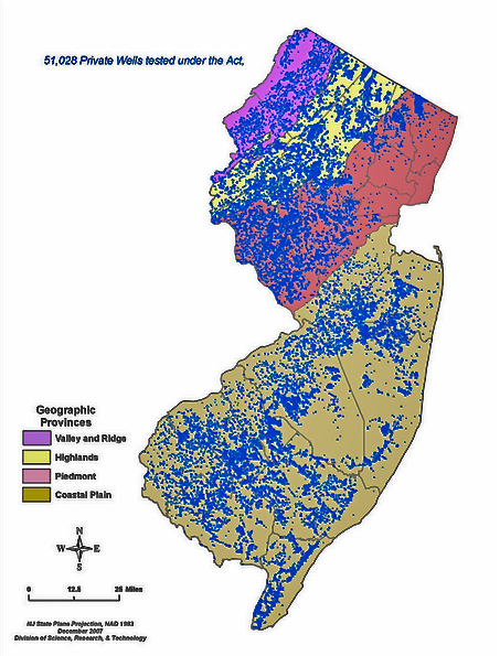
I knew they hated maps like above showing “The 51,028 wells sampled represents about 13% of the estimated 400,000 private wells used for drinking water in New Jersey.“
I also knew they are hiding maps of toxic groundwater plumes (see p. 15).
And we warned that DEP was suppressing this Big Risk map of toxic sites.
Not to forget that DEP is several years late in releasing the Water Supply Master Plan Update.
So, we all know they hate maps that can be linked to regulations, but what do they have against selling copies of the Wetlands Maps?
2/1/2011: NJDEP Freshwater Wetlands Maps (1986) No Longer for Sale
Effective February 2, 2011, the Department will no longer sell copies of the NJDEP Freshwater Wetlands Maps (1986). While the 1986 mapping is no longer available from the Department, you can access an updated version of the 1986 mapping online through the Department’s geographic information system (GIS) NJ-GeoWeb at www.nj.gov/dep/gis and choosing interactive mapping on the sidebar. The layer “Wetlands (2007)” is located under the land section of the layer manager. Be advised that the wetlands mapping is based on aerial photography and has not been ground verified through the Freshwater Wetlands “Letter of Interpretation” process. As such, they cannot be utilized for regulatory purposes.
Full size paper copies of the NJDEP Freshwater Wetlands Maps (1986) were distributed to all municipal clerk and county clerk’s offices for public use. If you have a need for this earlier mapping, please contact your municipality or county for availability and location. If you have general questions regarding freshwater wetlands regulations, please visit the NJDEP, Division of Land Use Regulation’s website at www.nj.gov/dep/landuse or call (609) 777- 0454 and choose the number one (1) for freshwater wetlands.
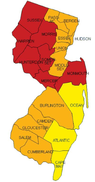
[Update: Oops! My bad! I forgot to mention one map that Christie and DEP love (drumroll: see below).
DEP loves it, because radon is naturally occurring. Nature doesn’t have powerful lawyers, lobbyists, and corporate campaign contributors. Any mitigation of radon risks are purely voluntary and the costs are borne by homeowners. And the people impacted tend to be rural northwest republicans.
They love it so much that Christie declared January Radon Action Month – and DEP is doing PR and urging people to sample indoor air in their homes.
But they forgot about the radon risks posed by drinking water and using that water indoors, for showers, cooking, etc.
So, why is DEP continuing to fail to develop drinking water “Maximum Contaminant Levels” (MCL’s) for radon and radionuclides recommended years ago by the NJ Drinking Water Quality Institute?
We exposed that DEP inaction here RADIOACTIVE WELLS POSE BIGGER RISKS IN NEW JERSEY — Hundreds of Thousands Exposed Daily to Rad Levels Many Times over Safety Limits
Now contrast DEP “Action” response to radon risks with INACTION in response to very similar risks from chemical vapor intrusion.
Vapor risks are caused by economically and politically powerful chemical companies,who have legions of lawyers and lobbyists. Remediation and mitigation must be obtained by DEP enforcement mandates. The costs are borne by the powerful chemical companies that caused the problem. The risk are borne primarily by urban democrats.
So DEP will not be releasing any Vapor Intrusion Risk maps or urging the public to test indoor air.
In fact, DEP just did the OPPOSITE. And that tells you everything you need to know about this Administration.
Now ain’t that a Tale of Two Risks!

source: Sussex Herald
